
By: Anna Taylor | Posted: Jan. 16, 2018 | Source: WVAH
CHARLESTON, W.Va. (WCHS/WVAH) — Snow is expected to continue to fall throughout the evening in the region, with the heaviest accumulation expected during the afternoon commute.
The latest round of winter weather has led to a number of school closings or dismissing early. Kanawha County Schools will be dismissing two hours early. Third Base and evening extracurricular activities also are canceled. Other schools districts closed for the day include Putnam, Cabell, Lincoln, Clay, Jackson, Mason, Harrison, Lewis, Gilmer, Barbour, Calhoun, Mingo, Wayne and Wirt. Wyoming County is dismissing at noon. Fayette County is closing three hours early.
In Ohio, the University of Rio Grande and Rio Grande Community College are closed and all athletic events have been canceled, a school spokeswoman said. Meanwhile in Kentucky, Boyd and Elliott counties are closed.
A winter weather advisory is in effect until 6 p.m. Tuesday for areas in West Virginia, Kentucky and Ohio.
West Virginia counties under the advisory issued by the National Weather Service in Charleston are Wayne, Cabell, Mason, Jackson, Wood, Pleasants, Tyler, Lincoln, Putnam, Kanawha, Roane, Wirt, Calhoun, Ritchie, Doddridge, Clay, Braxton, Gilmer, Lewis, Harrison, Taylor, Upshur and Barbour.
In Kentucky, counties under the watch include Greenup, Carter, Boyd and Lawrence.
Meanwhile, Ohio counties included are Meigs, Gallia and Lawrence.

A winter weather advisory is in effect until 6 a.m. Wednesday for Pocahontas County in West Virginia.
During a winter weather advisory for snow, periods of snow will cause travel difficulties. Slippery road conditions are expected. The National Weather Service advises drivers to be prepared for reduced visibilities at times.
In the Kanawha Valley, 2 to 4 inches of snow is expected. Some areas could see 5 inches. Kanawha County had less than an inch as of 8:30 a.m. The area can expect about an inch by noon and another 2 to 3 inches throughout the afternoon and evening. For the latest Eyewitness News Storm Team forecast, click here.
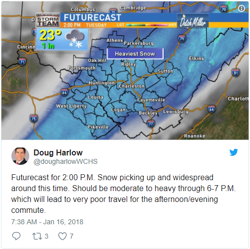
The heaviest snowfall is expected between 3 and 7 p.m. Tuesday.
Four minor crashes have been reported in the St. Albans and Cross Lanes areas since 6:30 a.m., according to Metro 911. In Athens County, Ohio, emergency officials said the county is under a level two snow emergency. Emergency officials said only those who feel it is necessary to travel should be out on the roads.
A flight from Yeager Airport to Charlotte has been canceled. For flight updates, go here.
Send your weather videos and photos here.