By: Jeff Jenkins | Posted: Mar. 13, 2018 at 3:47 p.m. | Source: WV MetroNews
CHARLESTON, W.Va. — Six to 12 inches of snow could accumulate in some of the state’s highest elevations by Wednesday afternoon, according to the National Weather Service.
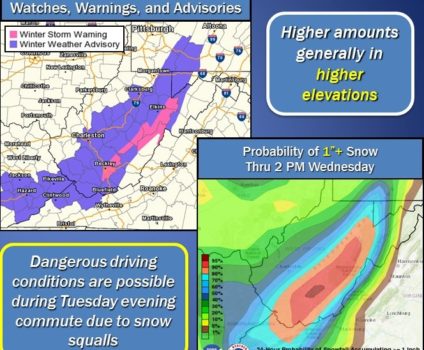
A Winter Storm Warning is in effect through Wednesday afternoon for parts of Tucker, Randolph, Raleigh, Fayette, Nicholas, Webster and Pocahontas counties with elevations at 3,000 feet or above expected to get the highest snowfall totals.
The National Weather Service details the latest forecast.
National Weather Service Meteorologist Maura Casey said this is a classic upslope snow event where the accumulation is directly related to the elevation.
“We get wind from the northwest which transports down Great Lakes moisture which hits our mountains and makes some snow for us,” Casey said.
A number of other counties including Kanawha, Roane, Calhoun, Mingo, Logan, Boone, Clay, Braxton,Gilmer, Lewis, Harrison,Taylor, Upshur and Barbour are under a Winter Weather Advisory until 11 a.m. Wednesday. Casey said the biggest threat in those areas will be heavy snow squalls.
“Wherever they do track over you can expect a quick inch or so, drops in visibility, hazardous driving,” she said.
Accumulations in the western lowlands will range from 1 to 4 inches with the possibility of five inches in some areas.
“If a snow squall doesn’t come across your area you may be dry,” Casey said. “Widespread snowfall amounts across the lowlands will be two inches or so with higher amounts the further east you go.”
You can reach Jeff Jenkins at jjenkins@wvradio.com and follow him on Twitter @JeffJenkinsMN. The award-winning native of Pratt, W.Va, took over as head of the news division of MetroNews in August 2000.