By: Jarrod Clay | Posted: Jan. 11, 2018 | Source: WVAH
CHARLESTON, W.Va. (WCHS/WVAH) — With heavy rain expected to turn to snow Friday evening, the National Weather Service in Charleston has issued a winter weather advisory for much of the viewing area.
The winter weather advisory is in effect from 4 p.m. Friday to 10 a.m. Saturday.
In West Virginia, the advisory includes Wayne, Cabell, Mason, Jackson, Wood, Pleasants, Tyler, Lincoln, Putnam, Kanawha, Roane, Wirt, Calhoun, Ritchie, Doddridge, Mingo, Logan, Boone, Clay, Braxton, Gilmer, Lewis, Harrison and Taylor County.
In Kentucky, the advisory includes Greenup, Carter, Boyd and Lawrence County. In Ohio, Morgan, Athens, Washington and Jackson County are under the advisory.
After a night of heavy rain Thursday, more rain is expected to move into the area at about 11 a.m. Friday. Late Friday evening an arctic cold front will move through the region and rain will turn to ice and snow as the temperature plummets.
Friday’s high is expected to be about 61 degrees, but it is expected to fall into the low 20s.
A tenth of an inch of ice could accumulate Friday night as the rain turns to snow and the temperature falls.
Most of the area can expect to see 2 to 4 inches of snow overnight, with some models showing the possibility of 6 to 7 inches.
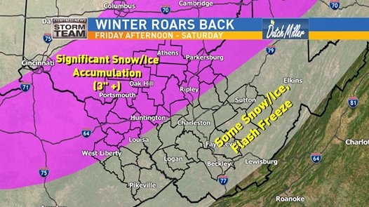
The overnight snow will make for treacherous road conditions Saturday morning.
The snow is expected to move out of the area Saturday afternoon.
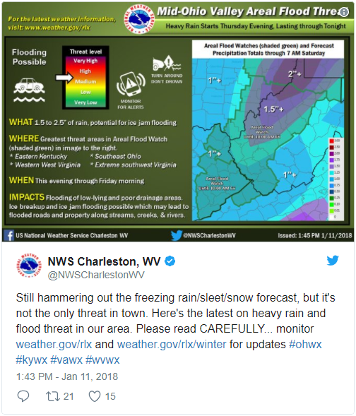
With heavy rain also expected Thursday night, much of the area was also placed under a flood watch through Friday morning.
For the latest updates, follow meteorologist Jim Barach, Doug Harlow and Brandon Stover on Twitter or head to the Eyewitness News weather page.
We want to see your videos and photos as this frigid system moves into the area. Send them to us here and we might use them online or on air.